Appleby | |
|---|---|
Locality | |
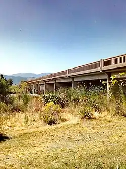 Appleby Bridge | |
| Coordinates: 41°18′58″S 173°08′06″E / 41.316°S 173.135°E | |
| Country | New Zealand |
| Territorial authority | Tasman |
| Ward | Richmond Ward |
| Electorates | |
| Government | |
| • Territorial Authority | Tasman District Council |
| • Mayor of Tasman | Tim King |
| • Nelson MP | Rachel Boyack |
| • Te Tai Tonga MP | Tākuta Ferris |
| Area | |
| • Total | 20.07 km2 (7.75 sq mi) |
| Population (June 2022)[2] | |
| • Total | 820 |
| • Density | 41/km2 (110/sq mi) |
| Time zone | UTC+12 (NZST) |
| • Summer (DST) | UTC+13 (NZDT) |
| Area code | 03 |
Appleby is a locality in the Tasman district in the South Island of New Zealand. It is located around the Waimea River near the Tasman Bay / Te Tai-o-Aorere. It was first settled in the early 1840s.[3] State Highway 60 passes through the settlement.
There are three buildings in Appleby registered with Heritage New Zealand:
- Springfield, a house on the corner of State Highway 60 and Cotterill Road, is registered as Category II with registration number 1646.[4]
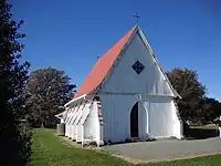
- St Alban's Church on State Highway 60 is registered as Category II with registration number 1654.[5]
- Stafford Place at 61 Redwood Road is registered as Category I with registration number 1678.[6]
In addition, the Redwood Racing Stables, which belonged to Stafford Place, were located on State Highway 60, and were relocated to Richmond, are registered as Category I with registration number 246.[7]
Demographics
The Appleby statistical area covers 20.07 km2 (7.75 sq mi).[1] It had an estimated population of 820 as of June 2022,[2] with a population density of 41 people per km2.
| Year | Pop. | ±% p.a. |
|---|---|---|
| 2006 | 744 | — |
| 2013 | 783 | +0.73% |
| 2018 | 786 | +0.08% |
| Source: [8] | ||
Appleby had a population of 786 at the 2018 New Zealand census, an increase of 3 people (0.4%) since the 2013 census, and an increase of 42 people (5.6%) since the 2006 census. There were 261 households, comprising 411 males and 378 females, giving a sex ratio of 1.09 males per female. The median age was 44.2 years (compared with 37.4 years nationally), with 147 people (18.7%) aged under 15 years, 147 (18.7%) aged 15 to 29, 381 (48.5%) aged 30 to 64, and 114 (14.5%) aged 65 or older.
Ethnicities were 88.9% European/Pākehā, 11.5% Māori, 4.6% Pasifika, 2.3% Asian, and 2.3% other ethnicities. People may identify with more than one ethnicity.
The percentage of people born overseas was 14.5, compared with 27.1% nationally.
Although some people chose not to answer the census's question about religious affiliation, 57.3% had no religion, 30.9% were Christian, 0.8% were Buddhist and 1.1% had other religions.
Of those at least 15 years old, 87 (13.6%) people had a bachelor's or higher degree, and 123 (19.2%) people had no formal qualifications. The median income was $31,200, compared with $31,800 nationally. 108 people (16.9%) earned over $70,000 compared to 17.2% nationally. The employment status of those at least 15 was that 336 (52.6%) people were employed full-time, 129 (20.2%) were part-time, and 21 (3.3%) were unemployed.[8]
Education
Appleby School is a state primary school for years 1 to 6 students.[9] It had a roll of 98 students as of April 2023.[10] The school opened on the current site in 1859.[11]
References
 Media related to Appleby, New Zealand at Wikimedia Commons
- 1 2 "ArcGIS Web Application". statsnz.maps.arcgis.com. Retrieved 29 July 2021.
- 1 2 "Population estimate tables - NZ.Stat". Statistics New Zealand. Retrieved 25 October 2022.
- ↑ "Appleby". Tasman District Council. Archived from the original on 4 December 2013. Retrieved 26 April 2014.
- ↑ "House (Springfield)". New Zealand Heritage List/Rārangi Kōrero. Heritage New Zealand. Retrieved 26 April 2014.
- ↑ "St Alban's Church". New Zealand Heritage List/Rārangi Kōrero. Heritage New Zealand. Retrieved 26 April 2014.
- ↑ "Stafford Place". New Zealand Heritage List/Rārangi Kōrero. Heritage New Zealand. Retrieved 26 April 2014.
- ↑ "Stafford Place". New Zealand Heritage List/Rārangi Kōrero. Heritage New Zealand. Retrieved 26 April 2014.
- 1 2 "Statistical area 1 dataset for 2018 Census". Statistics New Zealand. March 2020. Appleby (302200). 2018 Census place summary: Appleby
- ↑ Education Counts: Appleby School
- ↑ "New Zealand Schools Directory". New Zealand Ministry of Education. Retrieved 12 December 2022.
- ↑ "School History". Appleby School. Retrieved 29 July 2021.