   .svg.png.webp) Standard markers for Interstates, US highways, state-maintained and locally maintained state highways in Vermont. | |
| Highway names | |
|---|---|
| Interstates | Interstate X (I-X) |
| US Highways | U.S. Route X (US X) |
| State | Vermont Route X (VT Route X, VT X) |
| System links | |
The following is a list of state highways in Vermont as designated by the Vermont Agency of Transportation (VTrans). The classification of these state highways fall under three primary categories: Interstate Highways, U.S. Highways, and Vermont routes. Routes in Vermont are abbreviated as "VT #" by VTrans and also abbreviated as "VT Route #" and "Route #" in common usage. A small number of minor state highways, typically bypassing old alignments or short connector routes, are instead assigned names and unsigned four-digit numbers beginning with 9. Most state highways are maintained by VTrans; however, portions of some routes and some entire routes are maintained by local governments, such as towns or cities, instead. These town-maintained routes are internally called "state-designated town highways" and are typically designated as "class 1 town highways". Many of Vermont's state-numbered highways retain their numbers from when they were part of the New England road marking system of the 1920s; for instance, VT 9 was part of Route 9 of the New England system.
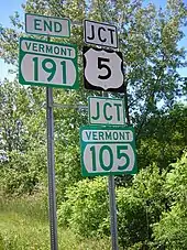
Prior to 1995, Vermont used the standard circular highway shield to sign all of its routes, which had black numerals on a white circle over a black background. In 1995, Vermont introduced a new shield for state-maintained highways—a green shield with the word "Vermont" at the top. The circular highway shield continues to be used for locally maintained routes.[1] Some state-maintained routes are still signed with the circular highway shield, but they are being converted to the newer Vermont shield as signs are replaced. Recent guide sign replacement projects along Vermont's Interstate Highways include the newer green shields to indicate Vermont state routes, as the older guide signs used the circular shield.
According to Vermont's 2012 Fact Book[2] the state spent $547 million in 2011. Less than half ($206 million) on preservation and maintenance. 28% of the roads remain in "very poor" condition. The book estimates $100 million would be required to reduce that to 25%.[3] The VTrans report to the legislature in 2012 appeared to disagree, stating that the goal of 25% in poor condition had been met.[3] The Burlington Free Press conducted a survey on 11% of the roads and found that signage was inadequate, often not warning drivers of dangerous curves; striping was inadequate, having been scraped off by winter snowplowing. Therefore, sides of the road could not be seen at night. Speed limit signs were placed near villages but nowhere else; guardrails were unpredictably placed. A spokesperson for VTrans agreed, citing fiscal restraints.[3] Troopers investigating accidents are not required to record road conditions which may have contributed to an accident.[3]
Interstate Highways
| Number | Length (mi)[4] | Length (km) | Southern or western terminus | Northern or eastern terminus | Formed | Removed | Notes | |
|---|---|---|---|---|---|---|---|---|
 I-89 I-89 |
130.254 | 209.623 | I-89 at the New Hampshire state line in Hartford | Route 133 at the Canadian border in Highgate | 1958 | current | Route 133 will be upgraded to a freeway and become A-35, expected completion in 2023[5] | |
| I-91 |
177.432 | 285.549 | I-91 at the Massachusetts state line in Guilford | A-55 at the Canadian border at Derby Line | 1958 | current | ||
 I-93 I-93 |
11.104 | 17.870 | I-93 at the New Hampshire state line in Waterford | I-91 in Waterford | 1982 | current | ||
 I-189 I-189 |
1.488 | 2.395 | US 7 in South Burlington | I-89 in South Burlington | 1962 | current | ||
 I-289 I-289 |
15.10 | 24.30 | Colchester | Williston | 1982 | 1986 | Partially built as VT 289 | |
| ||||||||
U.S. Highways
Mainline routes
| Number | Length (mi)[6] | Length (km) | Southern or western terminus | Northern or eastern terminus | Formed | Removed | Notes | |
|---|---|---|---|---|---|---|---|---|
 US 2 US 2 |
150.518 | 242.235 | US 2 at the New York state line in Alburgh | US 2 at the New Hampshire state line in Guildhall | 1926 | current | ||
 US 4 US 4 |
66.059 | 106.312 | US 4 at the New York state line in Fair Haven | US 4 at the New Hampshire state line in Hartford | 1926 | current | Mostly follows the old New England Route 13 in Vermont | |
 US 5 US 5 |
192.317 | 309.504 | US 5 at the Massachusetts state line in Guilford | QC 143 at the Canadian border at Derby Line | 1926 | current | Mostly follows the old New England Route 2; functionally bypassed by I-91 | |
| US 7 |
176.328 | 283.772 | US 7 at the Massachusetts state line in Pownal | I-89 in Highgate | 1926 | current | Mostly follows the old New England Route 4 | |
 US 302 US 302 |
35.746 | 57.528 | US 2 in Montpelier | US 302 at the New Hampshire state line in Wells River | 1935 | current | ||
Special routes
| Number | Length (mi)[6] | Length (km) | Southern or western terminus | Northern or eastern terminus | Formed | Removed | Notes | |
|---|---|---|---|---|---|---|---|---|
 US 2 Bus. US 2 Bus. |
0.887 | 1.427 | US 2 in Montpelier | US 2 / VT 12 in Montpelier | — | — | Business route in Montpelier | |
| US 4 Bus. |
4.371 | 7.034 | US 4 in West Rutland | US 4 / US 7 in city of Rutland | — | — | Business route through Rutland | |
 US 5 Alt. US 5 Alt. |
1.282 | 2.063 | US 5 in St. Johnsbury | US 5 in St. Johnsbury | — | — | Alternate route in St. Johnsbury | |
| US 5 Alt. |
0.604 | 0.972 | US 5 in Derby Line | I-91 in Derby Line | — | — | Alternate route in Derby Line | |
| US 5 Alt. |
1.283 | 2.065 | US 5 in city of Newport | US 5 in city of Newport | — | — | Alternate route in Newport | |
| US 7 Alt. |
2.107 | 3.391 | US 7 in Burlington | US 2 / US 7 in Burlington | — | — | Alternate route in Burlington | |
Vermont routes
All routes in Vermont are designated by the Vermont Agency of Transportation (VTrans). Most are also owned and maintained by VTrans, but some are partially or wholly owned and maintained by the towns it passes through instead. Routes maintained by VTrans are classified by the agency as "state-maintained highways" and signed using Vermont's green route shields. Routes maintained by the town are classified as "town-maintained routes" and signed using the national circular highway shield.
Five routes in the system have both state- and town-maintained sections. Although maintenance along these routes varies by area, VTrans considers state and town-maintained highways that bear the same signed number as one continuous route.
Designations shaded in gray are no longer active.
Numbered state highways
| Number | Length (mi)[7][8] | Length (km) | Southern or western terminus | Northern or eastern terminus | Formed | Removed | Notes | |
|---|---|---|---|---|---|---|---|---|
 VT 2A VT 2A |
13.853 | 22.294 | VT 116 in St. George | US 2 / US 7 in Colchester | — | — | ||
 VT 2B VT 2B |
3.459 | 5.567 | US 2 in Danville | US 2 in St. Johnsbury | — | — | ||
 VT 3 VT 3 |
7.828 | 12.598 | US 4 Business in Rutland | US 7 in Pittsford | — | — | ||
 VT 4A VT 4A |
14.174 | 22.811 | US 4 in Fair Haven | US 4 Business in West Rutland | — | — | ||
 VT 5A VT 5A |
19.498 | 31.379 | US 5 in Burke | VT 105 in Charleston | — | — | Mostly follows the old New England Route 2A | |
 VT 7A VT 7A |
27.820 | 44.772 | US 7 in Bennington | US 7 in Dorset | — | — | Follows an old segment of US 7 | |
 VT 7B VT 7B |
6.786 | 10.921 | US 7 in Wallingford | US 7 in Clarendon | — | — | ||
 VT 8 VT 8 |
13.155 | 21.171 | MA 8 at the Massachusetts state line in Readsboro | VT 9 in Searsburg | — | — | Mostly follows the old New England Route 8 | |
| VT 8A |
3.300 | 5.311 | MA 8A at the Massachusetts state line in Whitingham | VT 112 in Whitingham | — | — | Entirely town maintained | |
| VT 9 |
46.959 | 75.573 | NY 7 at the New York line in Bennington | NH 9 at the New Hampshire state line in Brattleboro | — | — | Mostly follows the old New England Route 9 | |
 VT 10 VT 10 |
4.373 | 7.038 | VT 103 in Chester | VT 106 in Springfield | — | — | ||
 VT 10A VT 10A |
0.522 | 0.840 | I-91 / US 5 in Norwich | NH 10A at the New Hampshire state line in Norwich | — | — | spur route of New Hampshire Route 10; unrelated to Vermont Route 10 | |
 VT 11 VT 11 |
42.154 | 67.840 | VT 7A in Manchester | NH 11 at the New Hampshire state line in Springfield | — | — | Mostly follows the old New England Route 11 | |
 VT 12 VT 12 |
101.627 | 163.553 | NH 12 at the New Hampshire state line in Weathersfield | VT 15A / VT 100 in Morrisville | — | — | ||
 VT 12A VT 12A |
20.842 | 33.542 | VT 12 in Randolph | VT 12 in Northfield | — | — | ||
 VT 14 VT 14 |
108.946 | 175.332 | US 4 / US 5 in Hartford | VT 100 in Newport | — | — | ||
 VT 15 VT 15 |
68.957 | 110.976 | US 2 / US 7 in Winooski | US 2 in Danville | — | — | ||
 VT 15A VT 15A |
1.824 | 2.935 | VT 12 / VT 100 in Morrisville | VT 15 in Morrisville | — | — | ||
  VT 16 VT 16 |
27.890 | 44.885 | VT 15 in Hardwick | VT 5A in Westmore | 1960[9] | current | Partially town maintained | |
 VT 17 VT 17 |
40.409 | 65.032 | NY 185 at the New York state line in Addison | VT 100 in Waitsfield | — | — | ||
 VT 18 VT 18 |
7.887 | 12.693 | NH 18 at the New Hampshire state line in Waterford | US 2 in St. Johnsbury | — | — | ||
 VT 19 VT 19 |
— | — | VT 30A in Bridport | VT 30 in Middlebury | 1935 | 1953 | ||
 VT 22A VT 22A |
44.738 | 71.999 | NY 22A at the New York state line in Fair Haven | US 7 in Ferrisburgh | — | — | spur route of New York Route 22 | |
 VT 23 VT 23 |
7.370 | 11.861 | VT 125 in Middlebury | VT 17 in Weybridge | — | — | Entirely town maintained | |
 VT 25 VT 25 |
17.739 | 28.548 | NH 25 at the New Hampshire state line in Bradford | US 302 in Orange | — | — | ||
 VT 25A VT 25A |
0.088 | 0.142 | US 5 in Fairlee | NH 25A at the New Hampshire state line in Fairlee | — | — | ||
 VT 25B VT 25B |
0.981 | 1.579 | VT 25 in Bradford | US 5 in Bradford | — | — | ||
 VT 26 VT 26 |
0.013 | 0.021 | VT 102 in Lemington | NH 26 at the New Hampshire state line in Lemington | — | — | ||
 VT 30 VT 30 |
111.870 | 180.037 | US 5 / VT 9 in Brattleboro | US 7 in Middlebury | — | — | ||
| VT 30A | — | — | US 4 / VT 30 in Fair Haven | US 7 in Vergennes | 1935 | 1945 | ||
| VT 30B | — | — | NY 149 at the New York state line in Pawlet | VT 30 in Pawlet | 1935 | 1966[10] | ||
 VT 31 VT 31 |
5.535 | 8.908 | Washington CR 25 at the New York state line in Wells | VT 30 in Poultney | 1966[10] | current | ||
 VT 35 VT 35 |
21.220 | 34.150 | VT 30 in Townshend | VT 11 in Chester | — | — | Entirely town maintained | |
  VT 36 VT 36 |
29.431 | 47.365 | VT 78 in Swanton | VT 108 in Bakersfield | — | — | Partially town maintained | |
 VT 38 VT 38 |
3.864 | 6.219 | US 7 in city of St. Albans | Northwest State Correctional Facility in town of St. Albans | — | — | ||
  VT 44 VT 44 |
10.190 | 16.399 | VT 106 in Reading | US 5 in Windsor | — | — | Partially town maintained | |
 VT 44A VT 44A |
2.994 | 4.818 | US 5 in Weathersfield | VT 44 in Windsor | — | — | ||
 VT 53 VT 53 |
9.310 | 14.983 | VT 73 in Brandon | US 7 in Salisbury | — | — | Entirely town maintained | |
 VT 56 VT 56 |
— | — | US 5 in Barton | VT 5A in Westmore | 1955 | 1986 | ||
  VT 58 VT 58 |
30.908 | 49.742 | VT 118 in Montgomery | VT 5A in Brownington | — | — | Partially town maintained | |
 VT 62 VT 62 |
4.519 | 7.273 | I-89 in Berlin | US 302 in Barre | — | — | ||
 VT 63 VT 63 |
3.901 | 6.278 | I-89 in Berlin | VT 14 in Barre | — | — | ||
 VT 64 VT 64 |
6.770 | 10.895 | VT 12 in Northfield | VT 14 in Williamstown | — | — | ||
 VT 65 VT 65 |
5.222 | 8.404 | VT 12 in Brookfield | VT 14 in Brookfield | — | — | ||
 VT 66 VT 66 |
7.621 | 12.265 | VT 12 in Randolph | VT 14 in Randolph | — | — | ||
 VT 67 VT 67 |
4.254 | 6.846 | NY 67 at the New York state line in Shaftsbury | VT 7A in Shaftsbury | — | — | ||
 VT 67A VT 67A |
3.348 | 5.388 | VT 7A in Bennington | VT 67 in Bennington | — | — | ||
 VT 68 VT 68 |
— | — | US 2 in Alburgh | QC 104 at the Canadian border in Alburgh | 1955 | 1985 | ||
  VT 73 VT 73 |
36.674 | 59.021 | VT 74 in Shoreham | VT 100 in Rochester | — | — | Partially town maintained | |
 VT 74 VT 74 |
13.263 | 21.345 | Fort Ticonderoga–Larrabees Point Ferry in Shoreham | VT 30 in Cornwall | — | — | ||
 VT 78 VT 78 |
21.126 | 33.999 | US 2 in Alburgh | VT 105 in Sheldon | — | — | ||
 VT 100 VT 100 |
216.666 | 348.690 | MA 8 at the Massachusetts state line in Stamford | VT 105 in Newport | — | — | ||
 VT 100A VT 100A |
6.971 | 11.219 | VT 100 in Plymouth | US 4 in Bridgewater | — | — | ||
 VT 100B VT 100B |
7.922 | 12.749 | VT 100 in Moretown | US 2 in Middlesex | — | — | ||
 VT 100C VT 100C |
4.595 | 7.395 | VT 15 in Johnson | VT 100 in Hyde Park | — | — | ||
 VT 101 VT 101 |
4.333 | 6.973 | VT 100 in Troy | VT 105 in Troy | — | — | ||
 VT 102 VT 102 |
43.755 | 70.417 | US 2 in Guildhall | VT 114 / VT 253 in Canaan | — | — | ||
 VT 103 VT 103 |
42.036 | 67.650 | US 5 in Rockingham | US 7 in Clarendon | — | — | ||
 VT 103A VT 103A |
— | — | US 7 in Wallingford | VT 103 in Mount Holly | 1948 | 1960 | ||
 VT 104 VT 104 |
20.503 | 32.996 | VT 15 in Cambridge | VT 105 in St. Albans | — | — | ||
 VT 104A VT 104A |
4.527 | 7.286 | US 7 in Georgia | VT 104 in Fairfax | — | — | ||
.svg.png.webp) VT 104B VT 104B |
— | — | US 7 / VT 104 in Swanton | VT 105 in Sheldon | 1935 | 1958 | ||
 VT 105 VT 105 |
98.135 | 157.933 | US 7 in St. Albans | Bridge Street at the New Hampshire state line in Bloomfield | — | — | ||
 VT 105A VT 105A |
1.799 | 2.895 | VT 105 in Richford | Chemin de la Vallée-Missisquoi at the Canadian border in Richford | — | — | ||
 VT 106 VT 106 |
25.963 | 41.783 | VT 11 in Springfield | US 4 in Woodstock | — | — | ||
 VT 107 VT 107 |
13.503 | 21.731 | VT 100 in Stockbridge | VT 14 in Royalton | — | — | ||
 VT 108 VT 108 |
45.450 | 73.145 | VT 100 in Stowe | QC 237 at the Canadian border in Berkshire | — | — | ||
 VT 109 VT 109 |
14.800 | 23.818 | VT 108 in Cambridge | VT 118 in Belvidere | — | — | ||
 VT 110 VT 110 |
27.136 | 43.671 | VT 14 in Royalton | US 302 in Barre | — | — | ||
 VT 111 VT 111 |
15.137 | 24.361 | VT 105 in Derby | VT 114 in Brighton | — | — | ||
 VT 112 VT 112 |
— | — | US 7 in Pownal | NY 346 at the New York state line in Pownal | 1926 | c. 1939 | renumbered VT 346 to match New York counterpart | |
 VT 112 VT 112 |
7.450 | 11.990 | MA 112 at the Massachusetts state line in Halifax | VT 100 in Whitingham | 1947 | current | ||
 VT 113 VT 113 |
22.847 | 36.769 | VT 110 in Chelsea | East Thetford Road at the New Hampshire state line in Thetford | — | — | ||
 VT 113A VT 113A |
— | — | VT 113 in Thetford | East Thetford Road at the New Hampshire state line in Thetford | 1935 | 1975 | ||
 VT 114 VT 114 |
53.094 | 85.447 | US 5 / VT 122 in Lyndon | Main Street at the New Hampshire state line in Canaan | — | — | ||
 VT 115 VT 115 |
— | — | US 7 in Brandon | VT 100 in Rochester | 1938 | 1967 | ||
 VT 116 VT 116 |
40.759 | 65.595 | US 7 in Middlebury | US 2 in South Burlington | — | — | ||
 VT 116A VT 116A |
— | — | VT 116 in St. George | US 2 in Williston | 1948 | 1973 | ||
  VT 117 VT 117 |
8.072 | 12.991 | VT 2A / VT 15 in Essex Junction | US 2 in Richmond | — | — | Partially town maintained | |
  VT 118 VT 118 |
28.549 | 45.945 | VT 100 in Eden | VT 108 in Berkshire | — | — | Partially town maintained | |
 VT 119 VT 119 |
0.080 | 0.129 | US 5 / VT 142 in Brattleboro | NH 119 at the New Hampshire state line in Brattleboro | — | — | ||
 VT 120 VT 120 |
10.554 | 16.985 | VT 105 in Sheldon | VT 108 in Berkshire | — | — | ||
 VT 121 VT 121 |
21.439 | 34.503 | VT 11 in Londonderry | US 5 in Bellows Falls | — | — | Entirely town maintained | |
 VT 122 VT 122 |
15.215 | 24.486 | US 5 / VT 114 in Lyndon | VT 16 in Glover | — | — | ||
 VT 123 VT 123 |
0.313 | 0.504 | US 5 in Westminster | NH 123 at the New Hampshire state line in Westminster | — | — | ||
 VT 125 VT 125 |
35.901 | 57.777 | VT 17 in Addison | VT 100 in Hancock | — | — | ||
  VT 127 VT 127 |
9.940 | 15.997 | Pearl Street in Burlington | US 2 / US 7 in Colchester | — | — | Main section, which is entirely town maintained; 0.142-mile-long (0.229 km) other section is state maintained | |
 VT 128 VT 128 |
11.616 | 18.694 | VT 15 in Essex | VT 104 in Fairfax | — | — | ||
  VT 129 VT 129 |
5.415 | 8.715 | School Street / Church Street in Isle La Motte | US 2 in Alburgh | — | — | Partially town maintained | |
 VT 130 VT 130 |
— | — | MA 112 at the Massachusetts state line in Halifax | VT 8 in Whitingham | 1935 | 1947 | ||
 VT 131 VT 131 |
16.299 | 26.231 | VT 103 in Cavendish | US 5 in Weathersfield | — | — | ||
  VT 132 VT 132 |
16.877 | 27.161 | VT 14 in Sharon | US 5 in Norwich | — | — | Partially town maintained | |
 VT 133 VT 133 |
22.476 | 36.172 | VT 30 in Pawlet | VT 4A in West Rutland | 1960[9] | current | ||
 VT 139 VT 139 |
1.822 | 2.932 | VT 105 in Richford | QC 139 at the Canadian border in Richford | — | — | Entirely town maintained | |
  VT 140 VT 140 |
25.059 | 40.329 | VT 30 in Poultney | VT 103 in Mount Holly | — | — | Partially town maintained | |
 VT 141 VT 141 |
0.493 | 0.793 | VT 114 in Canaan | QC 141 at the Canadian border in Canaan | 1960[9] | current | ||
 VT 142 VT 142 |
10.847 | 17.457 | MA 142 at the Massachusetts state line in Vernon | US 5 / VT 119 in Brattleboro | — | — | ||
 VT 143 VT 143 |
5.750 | 9.254 | VT 11 in Springfield | US 5 in Springfield | 1961[11] | current | Entirely town maintained | |
 VT 144 VT 144 |
6.910 | 11.121 | VT 22A in Benson | VT 30 in Sudbury | — | — | Entirely town maintained | |
 VT 147 VT 147 |
0.145 | 0.233 | VT 114 in Norton | QC 147 at the Canadian border in Norton | — | — | ||
 VT 149 VT 149 |
1.302 | 2.095 | NY 149 at the New York state line in Pawlet | VT 30 in Pawlet | 1966[10] | current | ||
 VT 153 VT 153 |
13.140 | 21.147 | Washington CR 153 at the New York state line in Rupert | VT 30 in Pawlet | 1961[11] | current | Entirely town maintained | |
 VT 155 VT 155 |
10.377 | 16.700 | VT 100 in Weston | VT 103 in Wallingford | 1961[11] | current | ||
 VT 191 VT 191 |
2.290 | 3.685 | I-91 in Derby | US 5 / VT 105 in Newport | — | — | ||
  VT 207 VT 207 |
13.821 | 22.243 | US 7 in St. Albans | VT 235 in Franklin | — | — | Partially town maintained | |
 VT 214 VT 214 |
2.061 | 3.317 | US 2 in Plainfield | VT 14 in East Montpelier | — | — | ||
 VT 215 VT 215 |
9.160 | 14.742 | US 2 in Marshfield | VT 15 in Walden | — | — | Entirely town maintained | |
 VT 225 VT 225 |
1.590 | 2.559 | US 2 in Alburgh | QC 225 at the Canadian border in Alburgh | — | — | Entirely town maintained | |
 VT 232 VT 232 |
13.548 | 21.803 | US 302 in Groton | US 2 in Marshfield | — | — | ||
 VT 235 VT 235 |
4.640 | 7.467 | VT 120 in Franklin | QC 235 at the Canadian border in Franklin | — | — | Entirely town maintained | |
 VT 236 VT 236 |
6.169 | 9.928 | VT 105 in Sheldon | VT 120 in Franklin | — | — | ||
 VT 242 VT 242 |
12.878 | 20.725 | VT 118 in Montgomery | VT 101 in Troy | — | — | ||
 VT 243 VT 243 |
1.181 | 1.901 | QC 243 at the Canadian border in North Troy | VT 105 in North Troy | — | — | ||
 VT 244 VT 244 |
5.640 | 9.077 | VT 113 in Thetford | US 5 in Fairlee | — | — | ||
 VT 253 VT 253 |
2.159 | 3.475 | VT 102 / VT 114 in Canaan | QC 253 at the Canadian border in Canaan | — | — | ||
 VT 279 VT 279 |
6.054 | 9.743 | NY 915G at the New York state line in Bennington | VT 9 in Bennington | 2004 | current | ||
 VT 289 VT 289 |
3.940 | 6.341 | VT 2A in Essex | VT 117 in Essex | — | — | ||
 VT 313 VT 313 |
10.050 | 16.174 | NY 313 at the New York state line in Arlington | US 7 in Sunderland | — | — | ||
 VT 314 VT 314 |
5.493 | 8.840 | US 2 in South Hero | US 2 in Grand Isle | 1964[12] | current | ||
 VT 315 VT 315 |
5.830 | 9.382 | VT 153 in Rupert | VT 30 in Rupert | — | — | Entirely town maintained | |
 VT 346 VT 346 |
4.628 | 7.448 | US 7 in Pownal | NY 346 at the New York state line in Pownal | c. 1939 | current | ||
| ||||||||
Ferry roads
| Number | Length (mi) | Length (km) | Southern or western terminus | Northern or eastern terminus | Formed | Removed | Notes | |
|---|---|---|---|---|---|---|---|---|
 VT F-1 VT F-1 |
— | — | — | — | — | — | ||
 VT F-2 VT F-2 |
— | — | — | — | c. 1935 | c. 1942 | ||
 VT F-3 VT F-3 |
— | — | — | — | c. 1935 | 1964[12] | Replaced by VT 314 | |
 VT F-4 VT F-4 |
— | — | — | — | — | — | ||
 VT F-5 VT F-5 |
2.890 | 4.651 | Charlotte–Essex ferry in Charlotte | US 7 in Charlotte | c. 1928 | current | ||
 VT F-6 VT F-6 |
— | — | — | — | c. 1930 | c. 1935 | ||
 VT F-7 VT F-7 |
— | — | — | — | c. 1927 | c. 1930 | Replaced by VT 17 | |
 VT F-8 VT F-8 |
— | — | — | — | c. 1926 | c. 1935 | ||
 VT F-9 VT F-9 |
— | — | — | — | c. 1927 | 1954[13] | ||
 VT F-9A VT F-9A |
— | — | — | — | c. 1930 | 1954[13] | ||
 VT F-10 VT F-10 |
— | — | — | — | c. 1930 | 1954[13] | ||
 VT F-10A VT F-10A |
— | — | — | — | c. 1930 | 1931 | ||
| ||||||||
Named state highways
These roads are maintained by the state but are not assigned signed route numbers.[14] The majority of them are minor connectors between two signed routes, making them similar to New York's reference routes. Unless a town is indicated in the southern or western terminus column, each highway is entirely within the town listed in the northern or eastern Terminus column.
| Number | Length (mi)[15] | Length (km) | Southern or western terminus | Northern or eastern terminus | Local names | Formed | Removed | Notes |
|---|---|---|---|---|---|---|---|---|
| VT 9020 | 0.806 | 1.297 | West Barnet Road | US 5 in Barnet | Barnet State Highway | — | — | I-91 exit 18 |
| VT 9025 | 0.236 | 0.380 | VT 7A | US 7 in Bennington | Bennington North State Highway | — | — | US 7 exit 2 |
| VT 9030 | 2.414 | 3.885 | Edward F. Knapp State Airport | US 302 in Berlin | Berlin State Highway | — | — | Includes Airport Road, 0.134-mile-long (0.216 km) concurrency with VT 62, and ramps from VT 62 to US 302 |
| VT 9090 | 0.135 | 0.217 | I-91 | US 5 / VT 9 in Brattleboro | Brattleboro State Highway | — | — | I-91 exit 3 |
| VT 9150 | 0.398 | 0.641 | VT 4A | East Hubbardton Road in Castleton | Castleton State Highway | — | — | US 4 exit 5 |
| VT 9160 | 0.914 | 1.471 | Rutland–Southern Vermont Regional Airport | VT 103 in Clarendon | Clarendon State Highway | — | — | Airport Road |
| VT 9180 | 2.630 | 4.233 | Newport State Airport in Coventry | US 5 in Newport | Coventry State Highway | — | — | Airport Road |
| VT 9210 | 0.598 | 0.962 | VT 4A | Scotch Hill Road in Fair Haven | Fair Haven State Highway | — | — | US 4 exit 3 |
| VT 9240 | 0.197 | 0.317 | US 5 | Lake Morey Road in Fairlee | Fairlee State Highway | — | — | I-91 exit 15 |
| VT 9270 | 0.799 | 1.286 | VT 22A in Vergennes | US 7 in Ferrisburgh | Ferrisburgh State Highway | — | — | Green Street and New Haven Road |
| VT 9330 | 0.602 | 0.969 | VT 102 | Maidstone Bridge at Connecticut River in Maidstone | Maidstone State Highway | — | — | Lamoreaux Road; leads to US 3 in Stratford, NH |
| VT 9360 | 0.170 | 0.274 | US 2 | Center Road in Middlesex | Middlesex State Highway | — | — | I-89 exit 9 |
| VT 9390 | 0.890 | 1.432 | I-89 | US 2 in Montpelier | Montpelier State Highway | — | — | I-89 exit 8; Memorial Drive |
| VT 9420 | 0.757 | 1.218 | Montpelier State Highway in Montpelier | Dog River Road at Montpelier–Berlin town line | Montpelier Junction State Highway | — | — | Intersects Montpelier Junction Road, which leads to Montpelier Amtrak station |
| VT 9430 | 0.482 | 0.776 | US 5 | Newbury Crossing at Connecticut River in Newbury | Newbury State Highway | — | — | Newbury Crossing Road; leads to NH 10 in Haverhill, NH |
| VT 9480 | 0.573 | 0.922 | VT 114 | VT 114 in Norton | Norton State Highway | — | — | Lake View Road; loop between two intersections with VT 114 |
| VT 9540 | 1.150 | 1.851 | VT 10A | US 5 in Norwich | Norwich State Highway | — | — | River Road |
| VT 9600 | 0.289 | 0.465 | Putney Landing Road | US 5 in Putney | Putney State Highway | — | — | I-91 exit 4 |
| VT 9630 | 0.123 | 0.198 | US 4 | Stagecoach Road in Hartford | Quechee State Highway | — | — | I-89 exit 1 |
| VT 9720 | 1.049 | 1.688 | US 7 in city of St. Albans | I-89 in town of St. Albans | St. Albans State Highway | — | — | I-89 exit 19; includes intersection with VT 104 |
| VT 9730 | 1.019 | 1.640 | US 5 | I-91 in St. Johnsbury | St. Johnsbury State Highway | — | — | I-91 exit 22; Hospital Drive |
| VT 9840 | 0.770 | 1.239 | I-91 | US 5 in Westminster | Westminster State Highway | — | — | I-91 exit 5; Westminster Street |
| VT 9870 | 0.744 | 1.197 | Christian Street | US 5 in Hartford | Wilder State Highway | — | — | I-91 exit 12; Bugbee Street |
| VT 9900 | 0.402 | 0.647 | Barnumville Road / New Ireland Road | VT 11 / VT 30 in Winhall | Winhall State Highway | — | — | Tollgate Road |
See also

References
http://www.vpr.net/news_detail/90914/
- ↑ State Numbered Town Highway Sign Details
- ↑ http://www.aot.state.vt.us/planning/Documents/Planning/2012VTransFactbook.pdf
- 1 2 3 4 Briggs, John (June 17, 2012). "Looking for a sign". Burlington Free Press. Burlington, Vermont. pp. 1A, 8A–9A.
- ↑ Traffic Research Unit (June 2016). "2015 (Route Log) AADTs: State Highways" (PDF). Technical Services Section, Vermont Agency of Transportation. pp. 7–8. Retrieved February 20, 2017.
- ↑ "L'autoroute 35 sera complétée d'ici 2023" (in French). Agence QMI. 9 October 2019. Retrieved 3 June 2020.
- 1 2 Traffic Research Unit (June 2016). "2015 (Route Log) AADTs: State Highways" (PDF). Technical Services Section, Vermont Agency of Transportation. pp. 11–26. Retrieved February 20, 2017.
- ↑ Traffic Research Unit (June 2016). "2015 (Route Log) AADTs: State Highways" (PDF). Technical Services Section, Vermont Agency of Transportation. pp. 29–66. Retrieved February 22, 2017.
- ↑ Traffic Research Unit (June 2015). "2014 (Route Log) AADTs: Major Collectors" (PDF). Technical Services Section, Vermont Agency of Transportation. pp. 3–17. Retrieved February 22, 2017.
- 1 2 3 "State Changes Route Numbers as Tourist Aid". The Burlington Free Press. December 31, 1959. p. 4. Retrieved May 2, 2018 – via Newspapers.com.

- 1 2 3 "Despite Delays in Federal Road Funds Holden Advises Highway Board to Maintain Preliminary Work". The Burlington Free Press. December 8, 1966. p. 36. Retrieved January 5, 2018 – via Newspapers.com.
- 1 2 3 "Vermont Highway Routes to be Revised in the Spring". The Bennington Banner. September 24, 1960. p. 2. Retrieved November 4, 2015 – via Newspapers.com.
- 1 2 "New State Route Numbers in Stamford, Readsboro". The Bennington Banner. April 23, 1964. p. 14. Retrieved November 4, 2015 – via Newspapers.com.
- 1 2 3 "3 Addison County Route Numbers Will be Changed". The Burlington Free Press. August 20, 1953. p. 9. Retrieved May 2, 2018 – via Newspapers.com.
- ↑ Vermont Agency of Transportation Program Development Division Traffic Research Unit, 2004 (Route Log) AADTs State Highways Archived 2007-10-27 at the Wayback Machine, July 2005
- ↑ Mapping Section (November 15, 2016). "VTrans Route Logs and Progress Charts". Named State Highways. Policy, Planning, and Intermodal Development Division, Vermont Agency of Transportation. Retrieved February 19, 2017.
- Barnet State Highway
- Bennington North State Highway
- Berlin State Highway:
- Brattleboro State Highway
- Castleton State Highway
- Clarendon State Highway
- Coventry State Highway:
- Fair Haven State Highway
- Fairlee State Highway
- Ferrisburgh State Highway:
- Maidstone State Highway
- Middlesex State Highway
- Montpelier State Highway
- Montpelier Junction State Highway
- Newbury State Highway
- Norton State Highway
- Norwich State Highway
- Putney State Highway
- Quechee State Highway
- St. Albans State Highway:
- St. Johnsbury State Highway
- Westminster State Highway
- Wilder State Highway
- Winhall State Highway