Étrepigney | |
|---|---|
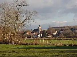 A general view of Étrepigney | |
 Coat of arms | |
Location of Étrepigney | |
  Étrepigney  Étrepigney | |
| Coordinates: 47°07′48″N 5°41′32″E / 47.13°N 5.6922°E | |
| Country | France |
| Region | Bourgogne-Franche-Comté |
| Department | Jura |
| Arrondissement | Dole |
| Canton | Mont-sous-Vaudrey |
| Government | |
| • Mayor (2020–2026) | Laurent Chenu[1] |
| Area 1 | 15.60 km2 (6.02 sq mi) |
| Population | 432 |
| • Density | 28/km2 (72/sq mi) |
| Time zone | UTC+01:00 (CET) |
| • Summer (DST) | UTC+02:00 (CEST) |
| INSEE/Postal code | 39218 /39700 |
| Elevation | 207–262 m (679–860 ft) |
| 1 French Land Register data, which excludes lakes, ponds, glaciers > 1 km2 (0.386 sq mi or 247 acres) and river estuaries. | |
Étrepigney (French pronunciation: [etʁəpiɲɛ]) is a commune in the Jura department in Bourgogne-Franche-Comté in eastern France.[3]
Population
|
|
See also
References
- ↑ "Répertoire national des élus: les maires" (in French). data.gouv.fr, Plateforme ouverte des données publiques françaises. 13 September 2022.
- ↑ "Populations légales 2020". The National Institute of Statistics and Economic Studies. 29 December 2022.
- ↑ INSEE commune file

Wikimedia Commons has media related to Étrepigney.

This article is issued from Wikipedia. The text is licensed under Creative Commons - Attribution - Sharealike. Additional terms may apply for the media files.