Aït Ali Si Embarek | |
|---|---|
| Motto: آيت علي سي أمبارك | |
 | |
| Coordinates: 36°41′02″N 3°34′07″E / 36.6838299°N 3.5687158°E | |
| Commune | Souk El-Had |
| District | Thénia District |
| Province | Boumerdès Province |
| Region | Kabylie |
| Country |  Algeria Algeria Algeria Algeria |
| Area | |
| • Total | 4.4 km2 (1.7 sq mi) |
| Dimensions | |
| • Length | 2 km (1 mi) |
| • Width | 2.2 km (1.4 mi) |
| Elevation | 460 m (1,510 ft) |
| Time zone | UTC+01:00 |
| Area code | 35020 |
Aït Ali Si Embarek is a village in the Boumerdès Province in Kabylie, Algeria.[1][2]
Location
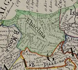
The village is surrounded by Isser River and Meraldene River and the towns of Souk El-Had, Thénia and Beni Amrane in the Khachna mountain range.[3][4][5]
Notable people
References
- ↑ "Le Soir du Centre". Djazairess.
- ↑ "Des villages désertés par leurs habitants". Djazairess.
- ↑ "«Le camp de torture Haouch Goutier, témoin des atrocités de l'occupant»". Djazairess.
- ↑ "Wilaya de Boumerdès : Souk El Had réclame un lycée". Djazairess.
- ↑ "Commune de Thénia : Les villageois manquent d'eau". Djazairess.
| A | |
|---|---|
| B | |
| C | |
| D | |
| E | |
| F | |
| G | |
| H | |
| L | |
| M | |
| O | |
| S | |
| T | |
| Z | |
This article is issued from Wikipedia. The text is licensed under Creative Commons - Attribution - Sharealike. Additional terms may apply for the media files.