Avrée | |
|---|---|
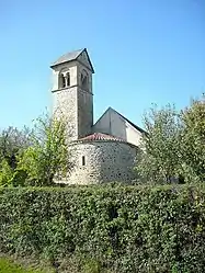 The church of Sainte-Madeleine, in Avrée | |
Location of Avrée | |
  Avrée  Avrée | |
| Coordinates: 46°49′10″N 3°52′13″E / 46.8194°N 3.8703°E | |
| Country | France |
| Region | Bourgogne-Franche-Comté |
| Department | Nièvre |
| Arrondissement | Château-Chinon (Ville) |
| Canton | Luzy |
| Intercommunality | CC Bazois Loire Morvan |
| Government | |
| • Mayor (2020–2026) | Georges Château[1] |
| Area 1 | 13.03 km2 (5.03 sq mi) |
| Population | 84 |
| • Density | 6.4/km2 (17/sq mi) |
| Time zone | UTC+01:00 (CET) |
| • Summer (DST) | UTC+02:00 (CEST) |
| INSEE/Postal code | 58019 /58170 |
| Elevation | 234–346 m (768–1,135 ft) |
| 1 French Land Register data, which excludes lakes, ponds, glaciers > 1 km2 (0.386 sq mi or 247 acres) and river estuaries. | |
Avrée (French pronunciation: [avʁe]) is a commune in the Nièvre department in central France.[3]
Geography
The river Alène flows northwest through the commune.
Population
| Year | Pop. | ±% |
|---|---|---|
| 1962 | 96 | — |
| 1968 | 141 | +46.9% |
| 1975 | 108 | −23.4% |
| 1982 | 119 | +10.2% |
| 1990 | 93 | −21.8% |
| 1999 | 99 | +6.5% |
| 2006 | 93 | −6.1% |
| 2009 | 94 | +1.1% |
| 2014 | 87 | −7.4% |
See also
References
- ↑ "Répertoire national des élus: les maires". data.gouv.fr, Plateforme ouverte des données publiques françaises (in French). 2 December 2020.
- ↑ "Populations légales 2020". The National Institute of Statistics and Economic Studies. 29 December 2022.
- ↑ INSEE commune file

Wikimedia Commons has media related to Avrée.

This article is issued from Wikipedia. The text is licensed under Creative Commons - Attribution - Sharealike. Additional terms may apply for the media files.