Ercé | |
|---|---|
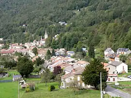 A general view of Ercé | |
Location of Ercé | |
  Ercé  Ercé | |
| Coordinates: 42°51′01″N 1°17′25″E / 42.8503°N 1.2903°E | |
| Country | France |
| Region | Occitania |
| Department | Ariège |
| Arrondissement | Saint-Girons |
| Canton | Couserans Est |
| Intercommunality | Couserans-Pyrénées |
| Government | |
| • Mayor (2020–2026) | Christian Carrère[1] |
| Area 1 | 40.75 km2 (15.73 sq mi) |
| Population | 569 |
| • Density | 14/km2 (36/sq mi) |
| Time zone | UTC+01:00 (CET) |
| • Summer (DST) | UTC+02:00 (CEST) |
| INSEE/Postal code | 09113 /09140 |
| Elevation | 574–1,905 m (1,883–6,250 ft) (avg. 620 m or 2,030 ft) |
| 1 French Land Register data, which excludes lakes, ponds, glaciers > 1 km2 (0.386 sq mi or 247 acres) and river estuaries. | |
Ercé (French pronunciation: [ɛʁse]; Occitan: Èrce) is a commune in the Ariège department in southwestern France.
Population
Inhabitants are called Ercéens.
| Year | Pop. | ±% |
|---|---|---|
| 1962 | 1,008 | — |
| 1968 | 1,012 | +0.4% |
| 1975 | 990 | −2.2% |
| 1982 | 750 | −24.2% |
| 1990 | 566 | −24.5% |
| 1999 | 532 | −6.0% |
| 2008 | 550 | +3.4% |
See also
References
- ↑ "Répertoire national des élus: les maires" (in French). data.gouv.fr, Plateforme ouverte des données publiques françaises. 13 September 2022.
- ↑ "Populations légales 2020". The National Institute of Statistics and Economic Studies. 29 December 2022.

Wikimedia Commons has media related to Ercé.

This article is issued from Wikipedia. The text is licensed under Creative Commons - Attribution - Sharealike. Additional terms may apply for the media files.