State Road 998 | ||||
|---|---|---|---|---|
| Route information | ||||
| Maintained by FDOT | ||||
| Length | 0.774 mi[1] (1,246 m) | |||
| Existed | 2019–present | |||
| Major junctions | ||||
| West end |  SR 997 in Homestead SR 997 in Homestead | |||
| East end |  US 1 in Homestead US 1 in Homestead | |||
| Location | ||||
| Country | United States | |||
| State | Florida | |||
| Counties | Miami-Dade | |||
| Highway system | ||||
| ||||


State Road 998 (SR 998) is an east–west road in Homestead, Florida, connecting the southern terminus of SR 997 with U.S. Route 1 (US 1). The road, known locally as Campbell Drive, North 8th Street and Southwest 312th Street runs just over 3⁄4 mile (1.2 km) and serves as a truck bypass around downtown Homestead. It is the highest numbered three-digit state highway in Florida.
Route description
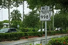
SR 998 starts at the intersection of Campbell Drive and Krome Avenue (SR 997 north/CR 997 south) and heads east, crossing the South Miami-Dade Busway, and ending at South Dixie Highway (US 1).
History
SR 998 was created in 2019 as part of a road swap between the Florida Department of Transportation (FDOT) and the county of Miami-Dade as part of FDOT's Krome Avenue widening project.[2][3] Since the portion of former SR 997 on Krome Avenue passes through a portion of downtown Homestead that could not accommodate a road widening, the state relinquished the highway to the county in exchange for Campbell Road entering the state highway system.[4][5]
Major intersections
The entire route is in Homestead, Miami-Dade County. [6][7]
| mi[1] | km | Destinations | Notes | ||
|---|---|---|---|---|---|
| 0.000 | 0.000 |  SR 997 north (Krome Avenue / Southwest 177th Avenue) SR 997 north (Krome Avenue / Southwest 177th Avenue) | Western terminus of SR 998; southern terminus of SR 997; Krome Avenue south is former SR 997 south. | ||
| 0.503 | 0.810 | South Miami-Dade Busway | |||
| 0.538 | 0.866 | Flagler Avenue | Former US 1 Bus. / SR 5A | ||
| 0.774 | 1.246 | US 1 (South Dixie Highway / SR 5) | Eastern terminus | ||
| 1.000 mi = 1.609 km; 1.000 km = 0.621 mi | |||||
References
- 1 2 District 6 (June 18, 2018). "Straight Line Diagram of Road Inventory 87290000" (PDF). Florida Department of Transportation. Retrieved December 13, 2019.
{{cite web}}: CS1 maint: numeric names: authors list (link) - ↑ "Legislative Matter".
- ↑ "FDOT District Six Construction: FDOT DISTRICT SIX CONSTRUCTION | MIAMI-DADE & MONROE COUNTIES | Florida Department of Transportation".
- ↑ "Homestead truck bypass rolling". 21 May 2014.
- ↑ "Legislative Matter".
- ↑ U.S. Census Bureau Geography Division (January 7, 2011). P.L. 94-171 County Block Map (2010 Census): Miami-Dade County, FL (PDF) (Map). U.S. Census Bureau. Index Sheet. Retrieved November 6, 2015.
- ↑ Google (December 13, 2019). "Location of Homestead, Florida" (Map). Google Maps. Google. Retrieved December 13, 2019.
External links
 Media related to Florida State Road 998 at Wikimedia Commons