| Mogods | |
|---|---|
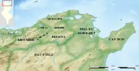 Map of the natural regions of Northern Tunisia | |
| Highest point | |
| Peak | Djebel Ichkeul |
| Elevation | 510 m (1,670 ft) |
| Geography | |
| Country | |
| Geology | |
| Age of rock | Precambrian |
The Mogods are Mountain ranges of Northern Tunisia, culminating at 500 meters height. They constitute the limit of the region of Khroumire.[1]
Location
The Mogods are situated between the seaside at north and the Medjerda River valley at the South, at the extremity of the Atlas Mountains.[2]
References
This article is issued from Wikipedia. The text is licensed under Creative Commons - Attribution - Sharealike. Additional terms may apply for the media files.