| Mount Almagosa | |
|---|---|
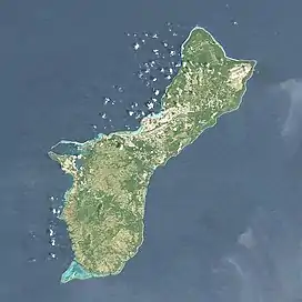  Mount Almagosa | |
| Highest point | |
| Elevation | 303 m (994 ft)[1] |
| Coordinates | 13°19′41″N 144°40′12″E / 13.32806°N 144.67000°E[1] |
| Geography | |
| Location | Guam, Micronesia, U.S. territory |
| Topo map | USGS Agat |
| Geology | |
| Mountain type | Mountain |
Mount Almagosa is the fourth highest peak on island of the United States territory of Guam.[2] It is west of the Fena Valley Reservoir.[3]
It is 303 meters (994 ft) above sea level.[1]
References
- 1 2 3 "Mount Almagosa". Geographic Names Information System. United States Geological Survey, United States Department of the Interior.
- ↑ "Highest Mountain Peaks in Guam". mountainzone.com. Mountain Zone. Archived from the original on 29 October 2013. Retrieved 15 January 2020.
- ↑ Tracey, Joshua (1964). General Geology of Guam. United States Government Printing Office. p. 29. Retrieved 15 January 2020.
This article is issued from Wikipedia. The text is licensed under Creative Commons - Attribution - Sharealike. Additional terms may apply for the media files.