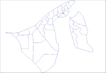
Mukim Amo | |
|---|---|
 Ulu Temburong National Park | |
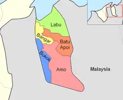 Amo is in red. | |
| Coordinates: 4°34′32″N 115°07′25″E / 4.5756533°N 115.1234737°E | |
| Country | Brunei |
| District | Temburong |
| Area | |
| • Total | 542 km2 (209 sq mi) |
| Population (2016)[2] | |
| • Total | 2,144 |
| • Density | 4.0/km2 (10/sq mi) |
| Time zone | UTC+8 (BNT) |
| Postcode | PDxx51 |
Mukim Amo is a mukim in Temburong District, Brunei. It has an area of 542 square kilometres (209 sq mi);[1] the population was 2,144 in 2016.[2]
Name
The mukim is named after Kampong Amo, one of the villages it encompasses.
Geography
The mukim is located in the eastern part of the district,[1] bordering Mukim Batu Apoi to the north-east, Mukim Bokok to the west and Mukim Bangar to north-west, as well as the Malaysian state of Sarawak to the east and south.
Hills
- Pagon Hill is the highest hill in the country with a height of 1,850 metres (6,070 ft).[3]
- Retak Hill has a height of 1,618 metres (5,308 ft).[4]
- Tudal Hill has a height of 1,181 metres (3,875 ft).[5]
Demography
As of 2016 census,[2] the population was 2,144 with 52.5% males and 47.5% females. The mukim had 421 households occupying 377 dwellings. The entire population lived in rural areas.
Administration
As of 2016, the mukim comprised the following census villages:[2]
| Village | Population (2016) |
|---|---|
| Kampong Amo[lower-alpha 1] | 507 |
| Kampong Batang Duri | 148 |
| Kampong Belaban[lower-alpha 2] | 21 |
| Kampong Biang | 75 |
| Kampong Parit[lower-alpha 3] | 288 |
| Kampong Selangan | 332 |
| Kampong Sibulu | 264 |
| Kampong Sibut[lower-alpha 4] | 202 |
| Kampong Sumbiling Baru[lower-alpha 5][lower-alpha 4] | 172 |
| Kampong Sumbiling Lama[lower-alpha 5][lower-alpha 4][lower-alpha 6] | 135 |
| Total | 2,144 |
Infrastructure
Schools
The government primary schools in the mukim include:
- Amo Primary School
- Selangan Primary School
Meanwhile, the government schools for the country's Islamic religious primary education include:
- Amo Religious School
- Selangan Religious School
Mosques
Notes
- ↑ Also administered as three villages i.e. Kampong Amo 'A', 'B' and 'C'
- ↑ Not to be confused with the village of the same name in Mukim Rambai, Tutong District
- ↑ Not to be confused with the villages of the same name in Mukim Kianggeh and Mukim Pengkalan Batu in Brunei-Muara District
- 1 2 3 Kampong Sibut and Kampong Sumbiling are administered under one village head since 1 March 2020.[6]
- 1 2 Kampong Sumbiling Baru and Kampong Sumbiling Lama are collectively known as Kampong Sumbiling.
- ↑ Not to be confused with the village of the same name in Mukim Sungai Kedayan, Brunei-Muara District
References
- 1 2 3 "Jabatan Daerah Temburong, Kementerian Hal Ehwal Dalam Negeri - MUKIM AMO". temburong.gov.bn (in Malay). Retrieved 8 January 2018.
- 1 2 3 4 "Population and Housing Census Update Final Report 2016" (PDF). www.deps.gov.bn. Statistics Department. December 2018. Retrieved 27 June 2021.
- ↑ "Highest And Lowest Points Of Countries Of The World". WorldAtlas. 20 May 2021. Retrieved 26 June 2022.
- ↑ Names, United States Board on Geographic (1952). Decision List - United States Board on Geographic Names. The Board. p. 72.
- ↑ Makowski, Christopher; Finkl, Charles W. (24 July 2018). Impacts of Invasive Species on Coastal Environments: Coasts in Crisis. Springer. p. 458. ISBN 978-3-319-91382-7.
- ↑ "Voting And Election Ceremony For Village Head". Brudirect.com. 28 June 2021. Retrieved 28 September 2021.
- ↑ "SenaraiMasjid - Masjid Kampong Selangan". www.kheu.gov.bn (in Malay). Retrieved 28 September 2021.
- ↑ "SenaraiMasjid - Balai Ibadat Kampong Sibut". www.kheu.gov.bn (in Malay). Retrieved 28 September 2021.
External links