Nesoddtangen | |
|---|---|
Village | |
 Indre Oslofjord and Bunnefjorden from Nesodden | |
| Country | Norway |
| Region | Østlandet |
| County | Akershus |
| District | Follo |
| Municipality | Nesodden |
| Population (2017) | |
| • Total | 12,803[1] |
| Time zone | UTC+01:00 (CET) |
| • Summer (DST) | UTC+02:00 (CEST) |
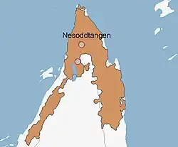
Urban area of Nesodden (2005)
Nesoddtangen is a village and the administrative centre of the municipality of Nesodden in Akershus, Norway.[2]
Nesoddtangen is located on the tip of the peninsula between the inner Oslofjord (Indre Oslofjord) and its arm Bunnefjorden. It is situated 4 miles (7 kilometers) southwest of Oslo. It had 13,150 residents in 2021; about two thirds of the municipality's population. Of the working population in Nesoddtangen, more than 90% work in Oslo. Passenger ferries are the most used commuting transportation.[3][4][5]
The name Nesoddtangen is a triple tautology, consisting of three parts, nes, odd and tangen, all being synonyms signifying a small cape or promontory.[6]
References
- ↑ "Viken (Norway): Municipalities & Settlements - Population Statistics, Charts and Map".
- ↑ Svein Askheim. "Nesoddtangen". Store norske leksikon. Retrieved October 1, 2016.
- ↑ "0541 Nesoddtangen". Statistisk sentralbyrå. January 1, 2015. Retrieved October 1, 2016.
- ↑ Svein Askheim (January 1, 2015). "Indre Oslofjord". Store norske leksikon. Retrieved October 1, 2016.
- ↑ "Oslo-Nesoddtangen". Tingvallakaia. January 1, 2015. Retrieved October 1, 2016.
- ↑ Haugen, Einar (1967) Norwegian-English Dictionary (University of Wisconsin Press) ISBN 978-0-299-03874-8
External links
This article is issued from Wikipedia. The text is licensed under Creative Commons - Attribution - Sharealike. Additional terms may apply for the media files.