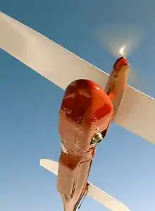
Pteryx UAV[1] is a Polish Miniature UAV designed for civilian use. It is manufactured and sold by TriggerComposites.[2] The machine is both a flying RC model and pre-programmed vehicle. It was awarded the Innowator Podkarpacia medal for innovative design in the category of micro-enterprises of the Podkarpacie region in 2010.[3][4]
Origin
The Pteryx UAV uses a custom derivation of the FLEXIPILOT software, designed by Aerial Robotics engineering group[5] for photomapping purposes and civilian use.
The avionics and flying platform are capable of full operational capability without using an active transmitter or ground station.
Capabilities
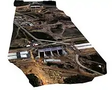
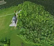
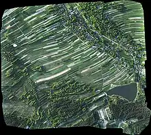
- Delivering data for generating digital elevation model using external photogrammetric software and orthorectification procedure[6]
- Delivering data for precision agriculture obtaining surface maps using mosaicking software
- Construction site and long-range linear mapping (up to around 40 km both ways with 2h flight time, reserve included)[7]
- Carrying custom research equipment
The camera mount contains either pre-installed compact digital camera, or can be exchanged for other equipment.
The camera can be mounted down-looking (nadir photography) or side-looking (oblique photography).
The whole head can be tilted in flight using RC transmitter, while reducing stabilization travel to one of the sides.
Features
Features included are:
- Flying multiple missions per day without reprogramming the autopilot (the waypoints being selected by mission selector and evaluated relative to takeoff)
- Exchangeable mission package
- Single button operation
- Fully enclosed camera head
- Ability to accommodate a weight range 200g-1000g
- Takeoff: using bungee, or bungee with rails.
- Landing: using parachute deployed automatically.
Precision
(manufacturer's data)
The aircraft provides positions of the photos taken; more than 8000 events can be recorded. Ground-projected positions include the following errors:
- GPS position error up to 5m.
- Altitude drift (up to 5m per 1 hour of flight)
- Camera head stabilization precision (transients up to 5°)
- Fuselage pitch due to turbulence (up to 8° during hot weather, typically 2° in winter)
- Camera mounting error (typically 1-4° if not calibrated)
- Heading/yaw error (the aircraft performs crabbing in presence of wind)
Typical orthophoto map precision (mean reprojection errors):
- 10 cm horizontal
- 30 cm vertical
- around 2.5m global shift to be removed with a few locally measured points
Data processing strategies
Several data processing approaches are possible depending on application:
- Direct photo examination
- Non-georeferenced image stitching using free software
- Using free 3D modelling services, as mentioned in examples section
- Importing each photo as ground overlay in Google Earth (semi-automatic with supplied software)
- Using pre-paid service based on cloud computing, yielding a result in hours (delivers Orto photomap and optionally DSM)
- Local processing using specialized GIS software created specifically for large scale image mosaicking (delivers Orto photomap and optionally DSM)
Aircraft components
- Fuselage
- 3-section wings with mounting screws
- Horizontal stabilizer section
- Parachute
Other required equipment
- LiPo batteries
- Laptop or netbook
- Compact digital camera
- RC controller compliant with local laws (see Radio-controlled aircraft Transmitting and Receiving Frequencies)
General characteristics
Masses:
- Maximum takeoff weight 5.0 kg
- Wingspan: 2.8 m
- Length: 1.4 m
- Height: 0.33 m
- Propulsion: brushless DC electric motor and rechargeable lithium polymer battery
- Endurance: 55min with 1 kg payload, 120min with 450g payload
- VC: around 50 km/h
- VS: 34–38 km/h depending on TOW
- VA: 120 km/h
- VNE: 160 km/h
Flight altitude:
- Service Ceiling 3000m Pteryx Lite
- Service Ceiling 1200m Pteryx Pro
- Cruise altitude 100-520m AGL, 250m typical - dictated by photo resolution
Handling:
- Assembly time: Around 5 minutes.
- Materials: Custom fiberglass composite material covered with durable red gelcoat, carbon fiber and Kevlar reinforcements, wood and other plastics. Wooden or all-composite wings are offered.
References
- ↑ "Archived copy". Archived from the original on 12 January 2012. Retrieved 12 May 2020.
{{cite web}}: CS1 maint: archived copy as title (link) - ↑ "Trigger Composites". www.t-cs.pl. Retrieved 4 January 2023.
- ↑ S.A, Telewizja Polska. "https://rzeszow.tvp.pl/272351/rzeszow". rzeszow.tvp.pl (in Polish). Retrieved 4 January 2023.
{{cite web}}: External link in|title= - ↑ "Laureaci i Wyróżnieni w konkursie Innowator Podkarpacia 2010". www.archiwum.podkarpackie.pl. Retrieved 28 October 2020.
- ↑ "Pteryx UAV". www6.aerialrobotics.eu. Archived from the original on 10 September 2010. Retrieved 4 January 2023.
- ↑ "Bezmiechowa 3D digital elevation model (AerialRobotics and CMP SfM Web Service)". Archived from the original on 20 July 2011. Retrieved 15 January 2011.
- ↑ Motorway mapping mission (YouTube video)
- ↑ "Archived copy" (PDF). Archived from the original (PDF) on 3 September 2011. Retrieved 7 March 2011.
{{cite web}}: CS1 maint: archived copy as title (link) - ↑ "Archived copy" (PDF). Archived from the original (PDF) on 3 September 2011. Retrieved 7 March 2011.
{{cite web}}: CS1 maint: archived copy as title (link)