Riverland | |
|---|---|
 Riverland | |
| Coordinates: 47°19′19″N 95°57′04″W / 47.32194°N 95.95111°W | |
| Country | United States |
| State | Minnesota |
| County | Mahnomen |
| Area | |
| • Total | 0.22 sq mi (0.56 km2) |
| • Land | 0.22 sq mi (0.56 km2) |
| • Water | 0.00 sq mi (0.00 km2) |
| Elevation | 1,214 ft (370 m) |
| Population (2020) | |
| • Total | 293 |
| • Density | 1,344.04/sq mi (519.05/km2) |
| Time zone | UTC-6 (Central (CST)) |
| • Summer (DST) | UTC-5 (CDT) |
| Area code | 218 |
| GNIS feature ID | 2583779[2] |
Riverland is a census-designated place and unincorporated community in Rosedale Township, Mahnomen County, Minnesota, United States. Its population was 276 at the 2010 census.[3]
Demographics
| Census | Pop. | Note | %± |
|---|---|---|---|
| 2020 | 293 | — | |
| U.S. Decennial Census[4] | |||
References
- ↑ "2020 U.S. Gazetteer Files". United States Census Bureau. Retrieved July 24, 2022.
- ↑ "Riverland". Geographic Names Information System. United States Geological Survey, United States Department of the Interior.
- ↑ "U.S. Census website". United States Census Bureau. Retrieved May 14, 2011.
- ↑ "Census of Population and Housing". Census.gov. Retrieved June 4, 2016.
Municipalities and communities of Mahnomen County, Minnesota, United States | ||
|---|---|---|
| Cities | 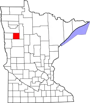 Map of Minnesota highlighting Mahnomen County | |
| Townships | ||
| CDPs | ||
| Unincorporated community | ||
| Indian reservations | ||
| Footnotes | ‡This populated place also has portions in an adjacent county or counties | |
This article is issued from Wikipedia. The text is licensed under Creative Commons - Attribution - Sharealike. Additional terms may apply for the media files.