Tuktukan | |
|---|---|
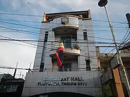
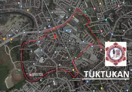
Barangay Hall of Tuktukan and Barangay Satellite View Map. | |
|
Seal | |
 Tuktukan | |
| Coordinates: 14°31′40.95″N 121°4′18.40″E / 14.5280417°N 121.0717778°E | |
| Country | Philippines |
| Region | National Capital Region |
| City | Taguig |
| District | 1st Legislative district of Taguig |
| Government | |
| • Type | Barangay |
| • Punong Barangay | Suranie Ulanday |
| Population (2015) | |
| • Total | 10,730[1] |
| Time zone | UTC+8 (PST) |
| Postal Code | 1637 |
| Area code | 02 |
| Website | https://www.facebook.com/barangay.tuktukan.50 |
Tuktukan is one of the 38 barangays of Taguig, Metro Manila, Philippines. It is the center of the city (Poblacion) where the City Hall of Taguig is located.[2]
Etymology
The word Tuktukan was coined by the Spanish as "Toctocan", which means an object to tap or to hit. When the Friar arrived at the place they saw a long queue of women doing their laundry by hitting it with a plank of wood or rock.
History
Based on the census 1980, Tuktukan has a population of 5,777. The total land area of the barangay is 31 hectares.[3]
Taguig seat of government was transferred to Tuktukan from Santa Ana on August 01, 1958 after President Carlos P. Garcia signed Executive Order number 311, s. 1958.[4]
Geography
Tuktukan is bounded on the North by Ususan. From the East by Calzada Tipas. To the South by Santa Ana. Then on the West by the Taguig River.
References
- ↑ Total Population by Province, City, Municipality and Barangay: as of May 1, 2010 Archived June 25, 2012, at the Wayback Machine - Philippine Statistics Authority
- ↑ "Barangay Tuktukan Taguig". ILoveTaguig. February 11, 2019.
- ↑ A gift of faith, 400 years. Quadricentennial (1587-1987) St. Anne Parish Tagig, Metro Manila; commemorative book page 52, circa 1987.
- ↑ https://www.officialgazette.gov.ph/1958/08/01/executive-order-no-311-s-1958/