Venha-Ver | |
|---|---|
Municipality | |
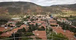
| The Municipality of Venha-Ver | |
 | |
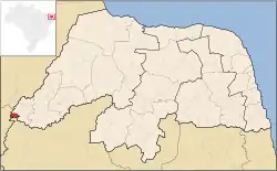 Location of Venha-Ver | |
| Coordinates: 06°19′33″S 38°29′02″W / 6.32583°S 38.48389°W | |
| Country |  Brazil Brazil |
| Region | Northeast |
| State |  Rio Grande do Norte Rio Grande do Norte |
| Founded | June 26, 1992 |
| Government | |
| • Mayor | Expedito Salviano (PR) |
| Area | |
| • Total | 71.622 km2 (27.653 sq mi) |
| Population (2020 [1]) | |
| • Total | 4,205 |
| • Density | 53.2/km2 (138/sq mi) |
| Time zone | UTC−3 (BRT) |
| HDI (2000) | 0.544 – medium[2] |
Venha-Ver (lit. "come see") is the westernmost city in the Brazilian state of Rio Grande do Norte. The city's name means "Come-to-see-it" in Portuguese. The highest point of the state is located there, in the Serra do Coqueiro mountain range, at the triple border of Rio Grande do Norte, Paraíba and Ceará.
References
This article is issued from Wikipedia. The text is licensed under Creative Commons - Attribution - Sharealike. Additional terms may apply for the media files.