Vilas, Colorado | |
|---|---|
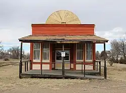 A former saloon on Main Street. | |
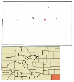 Location of Vilas in Baca County, Colorado. | |
| Coordinates: 37°22′27″N 102°26′49″W / 37.37417°N 102.44694°W | |
| Country |  United States United States |
| State |  Colorado Colorado |
| County[1] | Baca County |
| Incorporated | June 25, 1888[2] |
| Government | |
| • Type | Statutory Town[1] |
| Area | |
| • Total | 0.13 sq mi (0.33 km2) |
| • Land | 0.13 sq mi (0.33 km2) |
| • Water | 0.00 sq mi (0.00 km2) |
| Elevation | 4,154 ft (1,266 m) |
| Population | |
| • Total | 98 |
| • Density | 750/sq mi (300/km2) |
| Time zone | UTC-7 (Mountain (MST)) |
| • Summer (DST) | UTC-6 (MDT) |
| ZIP code[6] | 81087 (PO Box) |
| Area code | 719 |
| FIPS code | 08-81030 |
| GNIS feature ID | 0203869 |
Vilas is a statutory town located in Baca County, Colorado, United States. The population was 98 at the 2020 census.[5]
History
A post office called Vilas has been in operation since 1887.[7]
The community was named after William Freeman Vilas, a United States Senator from Wisconsin.[8]
Geography
Vilas is located in east-central Baca County at 37°22′27″N 102°26′49″W / 37.37417°N 102.44694°W (37.374134, -102.446928).[9] U.S. Route 160 passes just to the north of the town, leading west 11 miles (18 km) to Springfield, the county seat, and east 9 miles (14 km) to Walsh.
According to the United States Census Bureau, the town has a total area of 0.1 square miles (0.26 km2), all of it land.
Demographics
| Census | Pop. | Note | %± |
|---|---|---|---|
| 1940 | 129 | — | |
| 1950 | 132 | 2.3% | |
| 1960 | 107 | −18.9% | |
| 1970 | 83 | −22.4% | |
| 1980 | 118 | 42.2% | |
| 1990 | 105 | −11.0% | |
| 2000 | 110 | 4.8% | |
| 2010 | 114 | 3.6% | |
| 2020 | 98 | −14.0% | |
| U.S. Decennial Census | |||
See also
References
- 1 2 "Active Colorado Municipalities". State of Colorado, Department of Local Affairs. Archived from the original on December 12, 2009. Retrieved September 1, 2007.
- ↑ "Colorado Municipal Incorporations". State of Colorado, Department of Personnel & Administration, Colorado State Archives. December 1, 2004. Archived from the original on December 2, 2010. Retrieved September 2, 2007.
- ↑ "2019 U.S. Gazetteer Files". United States Census Bureau. Retrieved July 1, 2020.
- ↑ "US Board on Geographic Names". United States Geological Survey. October 25, 2007. Retrieved January 31, 2008.
- 1 2 United States Census Bureau. "Vilas town; Colorado". Retrieved April 28, 2023.
- ↑ "ZIP Code Lookup". United States Postal Service. Archived from the original (JavaScript/HTML) on November 22, 2010. Retrieved January 7, 2008.
- ↑ "Post offices". Jim Forte Postal History. Retrieved July 11, 2016.
- ↑ Dawson, John Frank. Place names in Colorado: why 700 communities were so named, 150 of Spanish or Indian origin. Denver, CO: The J. Frank Dawson Publishing Co. p. 50.
- ↑ "US Gazetteer files: 2010, 2000, and 1990". United States Census Bureau. February 12, 2011. Retrieved April 23, 2011.
External links

Wikimedia Commons has media related to Vilas, Colorado.
Municipalities and communities of Baca County, Colorado, United States | ||
|---|---|---|
| Towns |  Map of Colorado highlighting Baca County | |
| Unincorporated communities | ||
This article is issued from Wikipedia. The text is licensed under Creative Commons - Attribution - Sharealike. Additional terms may apply for the media files.