Highway 27 | ||||
|---|---|---|---|---|
 | ||||
| Route information | ||||
| Maintained by Alberta Ministry of Transportation | ||||
| Length | 151 km (94 mi) | |||
| Major junctions | ||||
| West end |   Hwy 22 / Hwy 584 in Sundre Hwy 22 / Hwy 584 in Sundre | |||
 Hwy 2A in Olds Hwy 2A in Olds Hwy 2 near Olds Hwy 2 near Olds Hwy 21 near Three Hills Hwy 21 near Three Hills | ||||
| East end |   Hwy 9 / Hwy 56 near Morrin Hwy 9 / Hwy 56 near Morrin | |||
| Location | ||||
| Country | Canada | |||
| Province | Alberta | |||
| Specialized and rural municipalities | Mountain View County, Kneehill County, Starland County | |||
| Towns | Sundre, Olds, Three Hills | |||
| Villages | Morrin | |||
| Highway system | ||||
|
| ||||
| ||||


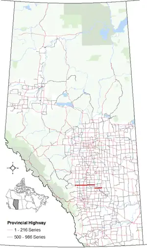
Alberta Provincial Highway No. 27, commonly referred to as Highway 27, is an east-west highway in central Alberta, Canada. It extends from Highway 22 in Sundre, through Olds along 46 Street, and intersects Highway 2 6 km (3.7 mi) east of Olds.[1] It continues east where it intersects Highway 21 4 km (2.5 mi) south of Trochu where it branches south, passes Three Hills, and branches east 10 km (6.2 mi) to the south. The highway ends at intersection of Highways 9 and 56, 5 km (3.1 mi) east of Morrin and 21 km (13 mi) north of Drumheller.[1][2]
Major intersections
From west to east:[3]
| Rural/specialized municipality | Location | km[1] | mi | Destinations | Notes |
|---|---|---|---|---|---|
| Mountain View County | Sundre | 0.0 | 0.0 | Hwy 584 west – Bearberry Hwy 22 north – Caroline, Rocky Mountain House | West end of Hwy 22 concurrency; through traffic follows Hwy 584 west |
| 2.0 | 1.2 | Crosses the Red Deer River | |||
| 2.3 | 1.4 |  Hwy 760 south – Bergen Hwy 760 south – Bergen | |||
| Westward Ho | 10.7 | 6.6 | Crosses the Little Red Deer River | ||
| | 12.4 | 7.7 | Hwy 22 south – Cochrane | East end of Hwy 22 concurrency | |
| 23.2 | 14.4 |  Hwy 766 Hwy 766 | |||
| Olds | 39.5 | 24.5 | Hwy 2A (46 Avenue) – Bowden, Didsbury | ||
| 44.4 | 27.6 | Hwy 2 – Edmonton, Red Deer, Calgary | Interchange; exit 340 on Hwy 2 | ||
| | 59.4 | 36.9 |  Hwy 791 Hwy 791 | ||
| Kneehill County | Torrington | 74.0 | 46.0 |  Hwy 805 – Wimborne, Linden Hwy 805 – Wimborne, Linden | |
| | 98.4 | 61.1 | Hwy 21 north – Trochu, Bashaw, Camrose | Hwy 27 branches south; north end of Hwy 21 concurrency | |
| Three Hills | 108.1 | 67.2 |  Hwy 583 (2nd Street N) Hwy 583 (2nd Street N) | ||
| | 114.5 | 71.1 |  Hwy 582 west – Didsbury Hwy 21 south – Strathmore Hwy 582 west – Didsbury Hwy 21 south – Strathmore | Hwy 27 branches east; south end of Hwy 21 concurrency | |
| 125.9 | 78.2 |  Hwy 836 – Carbon Hwy 836 – Carbon | |||
| 132.4 | 82.3 |   Hwy 837 south – Bleriot Ferry Hwy 837 south – Bleriot Ferry | |||
| ↑ / ↓ | | 138.4 | 86.0 | Crosses the Red Deer River | |
| Starland County | | 143.2 | 89.0 |  Hwy 839 north – Rumsey Hwy 839 north – Rumsey | |
| 148.1 | 92.0 | UAR 113 north – Morrin | |||
| 151.4 | 94.1 | Hwy 9 / Hwy 56 – Hanna, Stettler, Drumheller, Calgary | Through traffic follows Hwy 9 east | ||
1.000 mi = 1.609 km; 1.000 km = 0.621 mi
| |||||
References
Template:Attached KML/Alberta Highway 27
KML is not from Wikidata
- 1 2 3 Google (January 2, 2018). "Highway 27 in Alberta" (Map). Google Maps. Google. Retrieved January 2, 2018.
- ↑ "2015 Provincial Highway 1-216 Progress Chart" (PDF). Alberta Transportation. March 2015. Archived (PDF) from the original on April 10, 2016. Retrieved October 12, 2016.
- ↑ Alberta Road Atlas (2005 ed.). Oshawa, ON: MapArt Publishing Corp. pp. 69, 70, and 71
This article is issued from Wikipedia. The text is licensed under Creative Commons - Attribution - Sharealike. Additional terms may apply for the media files.